Loading / 加载中...
Back to Industry SolutionsAgriculture Solutions · AGRICULTURE PANORAMIC VIDEO
Agricultural Machinery Panoramic Video Solution
Multi-Camera Stitching + Panoramic-PTZ Linkage + AI Recognition · Improving Agricultural Machinery Operation Efficiency
Designed for agricultural machinery operations in farming, harvesting, and agricultural parks, the system stitches five video feeds (front, rear, left, right, top) into a continuous panoramic view. It supports PTZ camera linkage for detail inspection ("click-to-view") and AI-based machinery type recognition, operation status detection, area calculation, and efficiency analysis — providing one-screen management of agricultural machinery operations.
Stitch
5→1 Panoramic View
Link
PTZ Click-to-View
AI
Recognition & Efficiency
Data
Big Data Platform
Industry Pain Points
01
Difficult Machinery Monitoring
Agricultural machinery operations are scattered across multiple plots. Traditional multi-window layouts fragment the view, making it impossible for managers to grasp all machinery positions and status in one field of view.
02
Manual Area Statistics
Operation area relies on driver reports or manual measurements, with inconsistent metrics, lagging data, and susceptibility to underreporting or false reporting — lacking objective settlement basis.
03
Vague Efficiency Assessment
No automated mechanism for converting operation duration into area metrics, making it impossible to accurately calculate individual machine efficiency and leaving dispatch decisions without data support.
04
Panorama-Detail Disconnection
Panoramic cameras provide wide视野 but lack machinery detail; PTZ cameras show local details but lose global position context. No linkage exists between the two.
Solution Overview
Agriculture Panoramic
Upgrade agricultural machinery monitoring from multi-window to AI panoramic video
The solution uses panoramic video as the main display, fusing five on-machine camera feeds into one continuous view. It integrates PTZ linkage for detail inspection at the click of a target, and AI recognition that automatically identifies machinery type, operation status, coverage area, and efficiency metrics — delivering data-driven management for agricultural operations.
✓
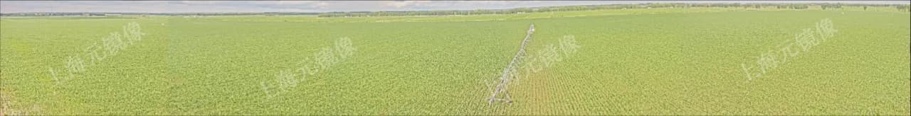
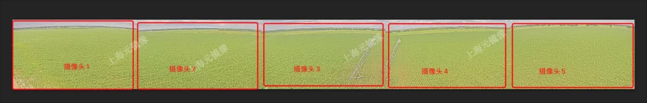
Multi-Camera Stitching to Panoramic View
Real-time stitching of five independent video feeds (front, rear, left, right, top) into a continuous panoramic view, giving one-screen awareness of the machinery's full surroundings.
✓
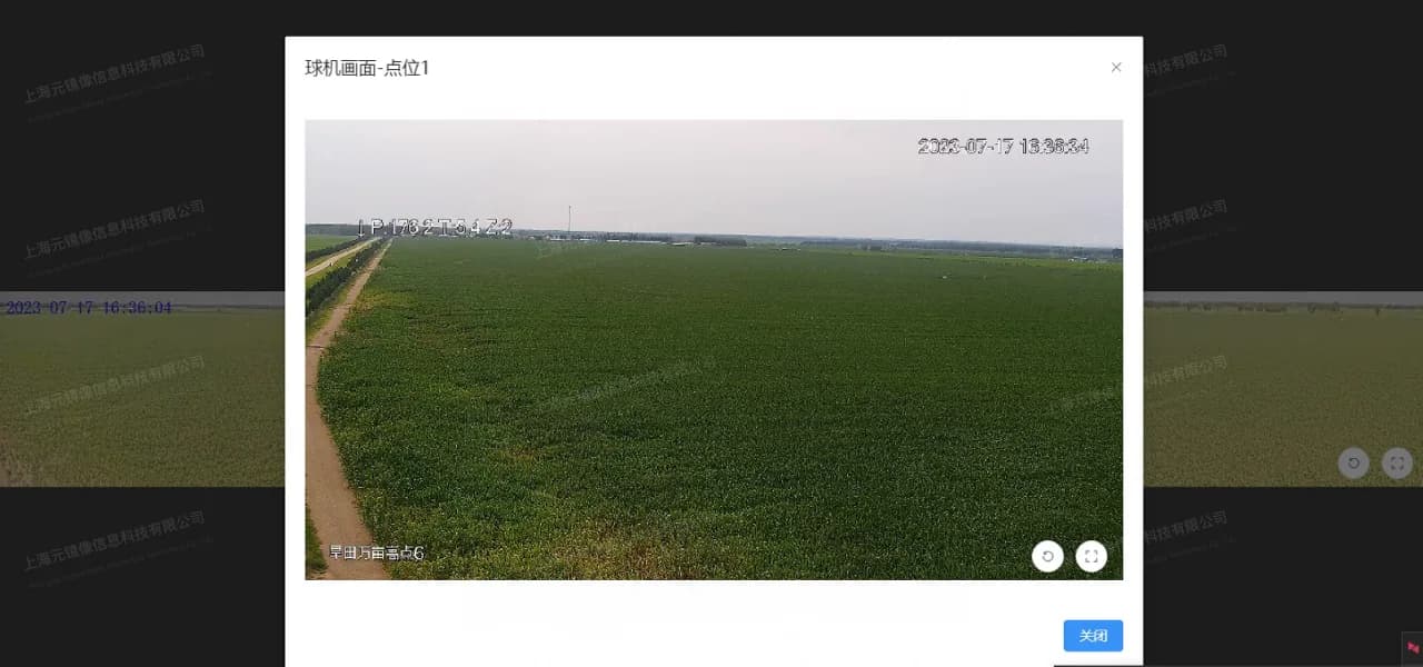
Panoramic-PTZ Linkage for Detail View
Click any area or machinery target on the panoramic view to auto-zoom the PTZ camera for magnified, locked-on tracking — "click-to-view" fine inspection.
✓
AI Recognition & Efficiency Analysis
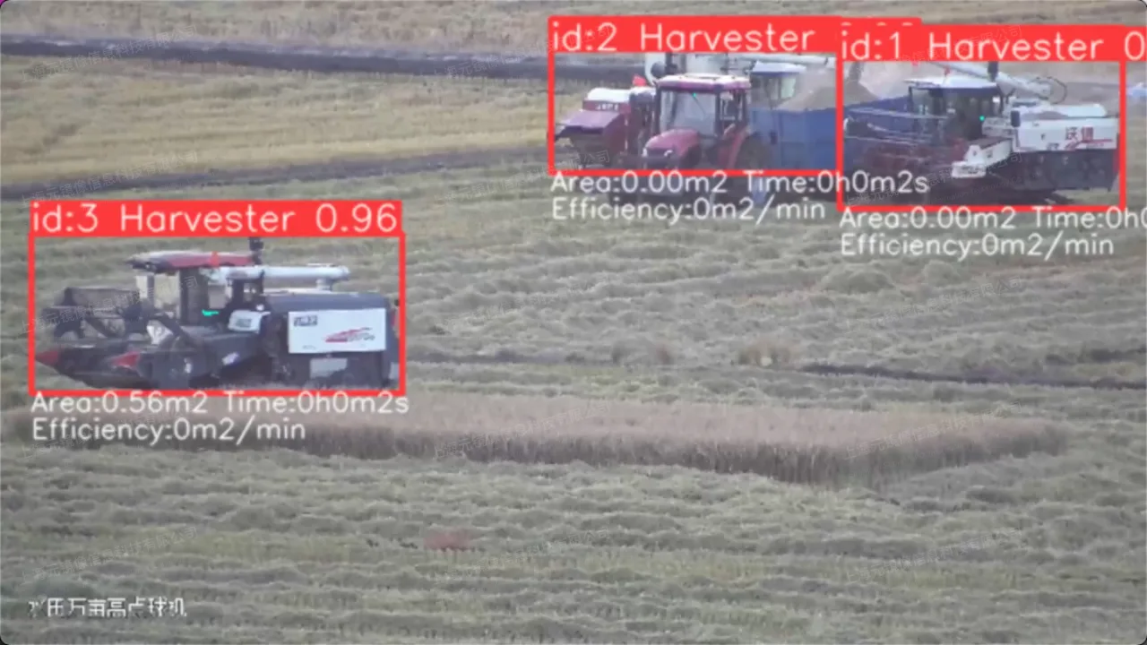
Automatically identify machinery type, operation status, and travel trajectory via AI deep learning, calculate operation coverage area and efficiency metrics with positioning data, providing objective basis for assessment.
✓
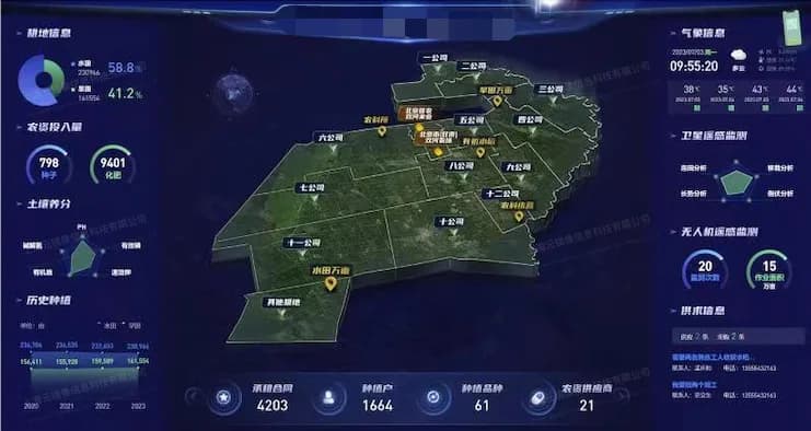
Modern Agricultural Big Data Platform
Aggregate multi-dimensional data including panoramic video, AI recognition, area and efficiency statistics to build an agricultural production big data platform, providing data-driven decision support for agricultural management.
Technical Architecture
Architecture Overview
From video capture to AI analysis, end-to-end intelligent pipeline
The system covers the full pipeline from multi-channel video capture on the machinery, real-time panoramic stitching and fusion, PTZ linkage control for detail inspection, to AI recognition and efficiency analysis. Each layer is modular and can be deployed flexibly based on site requirements.
视频采集
拼接融合
球机联动
AI识别
01
Five-Channel Video Capture
Deploy five HD cameras on the machinery body (front, rear, left, right, and top), covering 360° surroundings and the operation field of view.
02
Real-Time Stitching & Fusion
Complete real-time calibration, distortion correction, color统一, and seamless stitching of five video feeds through the stitching gateway, outputting one panoramic video.
03
PTZ Linkage Control
Click a target area on the panoramic view; the system automatically calculates target coordinates and drives the PTZ camera to zoom, focus, and position on that area.
04
AI Recognition & Statistics
Perform AI inference on the stitched video stream to recognize machinery type, operation status, and travel trajectory, calculating operation area and efficiency with positioning data.
Core Features
Feature 01
Real-Time Multi-Camera Stitching
Stitches five independent video feeds (front, rear, left, right, top) into one continuous panoramic video, eliminating multi-window fragmentation and giving managers complete spatial awareness around the machinery.
Feature 02
Click-to-View Panoramic-PTZ Linkage
Click any target area on the panoramic view to auto-zoom the PTZ camera for magnified detail, locking onto the target for tracking. Preserves global context while never missing local detail — seamless panorama-to-detail switching.
Feature 03
AI Recognition & Efficiency Analysis
Leveraging deep learning algorithms to automatically identify machinery type (harvester, seeder, rotary tiller, etc.), operation status, and travel trajectory. Combined with positioning data, it calculates per-machine coverage area, operation duration, and travel distance, generating efficiency reports for dispatch, assessment, and settlement.
Feature 04
Modern Agricultural Big Data Platform
Aggregates multi-dimensional data from agricultural machinery operations — panoramic video, AI recognition results, area and efficiency statistics — to build a comprehensive big data platform, empowering agricultural management with data-driven decision support.
Use Cases
01
Field Cultivation
During seeder and rotary tiller operations, panoramic stitching presents machinery positions and cultivated areas in real time, with AI识别 operation row count and coverage trajectory.
02
Harvesting Operations
Panoramic tracking of harvester paths during harvesting, with AI识别 harvested area and progress, assisting coordination between harvesting vehicles and transport vehicles.
03
Machinery Dispatch Management
When multiple machines operate simultaneously, the dispatch center monitors each machine's position, status, and efficiency on one screen for合理 task allocation and route adjustment.
04
Agricultural Park Surveillance
Panoramic video surveillance of operation vehicles, transport vehicles, and personnel in large agricultural parks, with PTZ linkage for detail inspection to ensure park safety.
Case Studies
01
Case Study: Agricultural Machinery Panoramic Stitching Before/After
Before stitching: five independent video feeds (front/rear/left/right/top) requiring switching between multiple windows to assess machinery surroundings. After stitching: one continuous panoramic video presents the full 360° environment around the machinery, with AI recognition and PTZ linkage for detail viewing.
Feature List
| Feature | Supported |
|---|---|
| Real-time stitching of five video feeds (front/rear/left/right/top) into one panoramic view | ✓ |
| Click any area on the panoramic view to trigger PTZ zoom for detail inspection | ✓ |
| AI automatically识别 machinery type, operation status, and travel trajectory | ✓ |
| Automatic calculation of machinery operation coverage area | ✓ |
| Operation duration statistics and efficiency metric conversion | ✓ |
| Simultaneous multi-machine detection and tracking on one screen | ✓ |
| Daily/weekly/monthly operation efficiency report generation | ✓ |
| Panoramic historical playback by time, area, and machinery target | ✓ |
| Alert information highlighted and positioned on the panoramic view | ✓ |
| Integration with agricultural management platforms and GIS systems | ✓ |
| Build a modern agricultural production big data platform aggregating multi-dimensional farming data | ✓ |
| Support for large-screen display, B/S player, and video stream output | ✓ |
Solution Value
✓
Upgrade from multi-window monitoring to single panoramic view, reducing management cognitive load
✓
Panoramic-PTZ linkage balances global awareness with local detail inspection
✓
AI machinery recognition replaces manual statistics with objective, traceable operation area data
✓
Automatic efficiency calculation provides data support for performance assessment and dispatch decisions
✓
Simultaneous monitoring of multiple machines improves machinery resource utilization
✓
Build an agricultural big data platform to provide comprehensive data support for management decisions
✓
Reuse existing cameras and monitoring platforms for phased deployment by plot or park
Get the Agricultural Machinery Panoramic Video Solution
Supporting on-site assessment, camera deployment, panoramic stitching debugging, PTZ linkage configuration, AI model training, and platform integration
Related Products